跳到主要內容Skip to content
03 — 系統組成Composition & Structure

兩種節點、三台載具,
共用同一套無線系統。

Two node types, three vehicles,
one shared wireless system.

節點本體以 模組化零件構成,LoRa ESP32-S3 為主控 —— 讀取感測器、封裝資料並排程發送。點擊任一單元展開完整規格。

Body built with modular parts; LoRa ESP32-S3 is the main controller — it reads sensors, packs the data, and schedules transmission. Click any unit to expand its full spec.

以 模組化零件構成本體,LoRa ESP32-S3 為主控 —— 讀取感測器、封裝資料並排程發送。 心率/血氧感測器即時回傳受困者的生命徵象;外掛的小型 LoRa 無線模組提供長距離、低功耗的資料鏈路。

Body built with modular parts; LoRa ESP32-S3 is the main controller — it reads sensors, packs the data, and schedules transmission. Heart rate / SpO₂ sensors send victims’ vital signs in real time, and a small add-on LoRa module gives long-range, low-power data links.

主控ControllerLoRa ESP32-S3
生理感測Vital signs心率 / 血氧Heart rate / SpO₂
無線WirelessLoRa 外掛模組LoRa add-on module
本體Body模組化零件modular parts
電池續航Battery life約 120 小時(一般回報)~120 h (normal duty)
生存信標節點 Survival Beacon Node
待放檔案File missing 把照片存成 assets/sbn.jpg 就會自動顯示。 Save the photo as assets/sbn.jpg and it appears automatically.
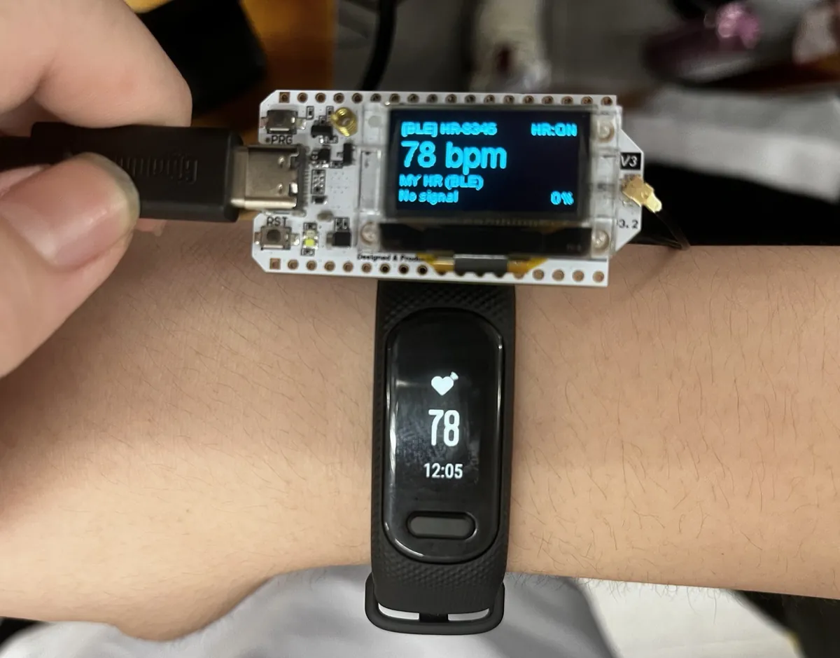
節點讀到 78 bpm,與手腕上的心率手環讀值一致 The node reads 78 bpm — matching the wrist band on the same arm

同樣以 模組化零件構成本體、LoRa ESP32-S3 為主控。土壤含水量/坡度/水位感測器全天候監看二次災害的徵兆, 並與生存信標共用同一套無線系統 —— 這是「平時守護山林」的那一半。

Also built with modular parts and controlled by LoRa ESP32-S3. Soil moisture / slope / water level sensors watch for second disasters day and night, and it shares the same wireless system as the Survival Beacon — this is the “guarding the forest” half of the system.

主控ControllerLoRa ESP32-S3
環境感測Environment土壤含水 / 坡度 / 水位Soil / slope / water level
無線Wireless與信標同一套Same as the beacon
監看Monitoring全天候 · 二次災害24/7 · second disasters
回報週期Report interval每 5 分鐘(異常即報)Every 5 min (alert on threshold)
環境感測節點 Sensor Node
待放檔案File missing 把照片存成 assets/sensor-node.jpg 就會自動顯示。 Save the photo as assets/sensor-node.jpg and it appears automatically.
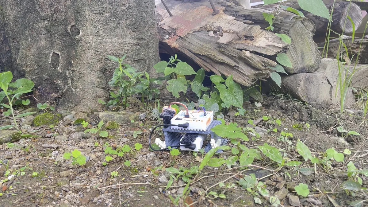
環境感測節點 · 野地部署 Sensor Node · deployed in the field

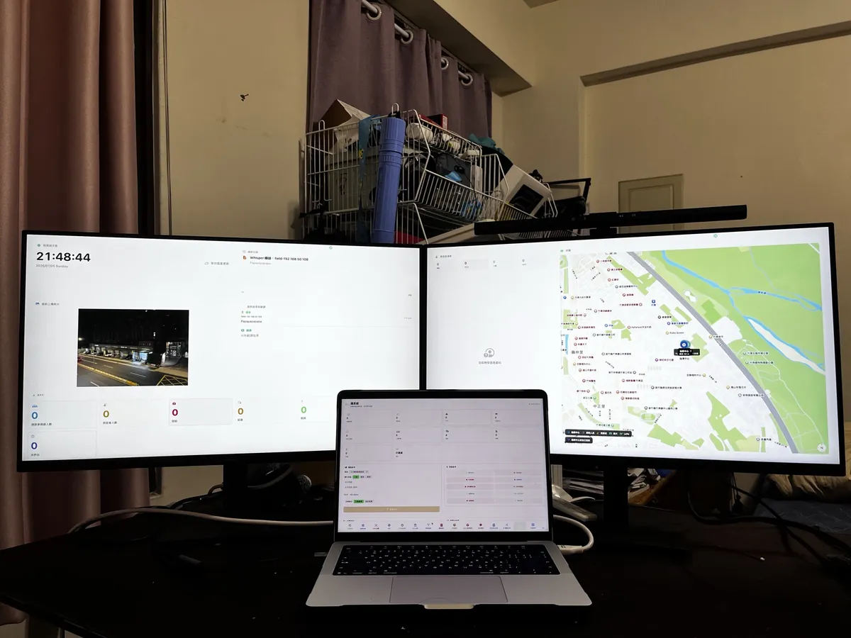
資訊與決策的大腦,AI 於本地端運算、無需網際網路。ICS 五級角色權限、地圖點線面標記、離線同步; 即時儀表板顯示上線裝置、受困者統計與 SOS 警報。

The brain for information and decisions; the AI runs locally, no internet needed. ICS five-role permission levels, map marking (points, lines, areas) and offline sync. A live dashboard shows online devices, victim statistics, and SOS alerts.

平台Platform平板 / 筆電Tablet / laptop
AI本地端 · 離線On-device · offline
權限RolesICS 五級角色ICS five levels
地圖Map點 / 線 / 面標記Points / lines / areas
同步Sync離線佇列Offline queue
指揮中心 Command Center
待放檔案File missing 把照片存成 assets/cmd.jpg 就會自動顯示。 Save the photo as assets/cmd.jpg and it appears automatically.
指揮中心 · 雙螢幕戰情台與地圖 Command Center · dual-screen situation display

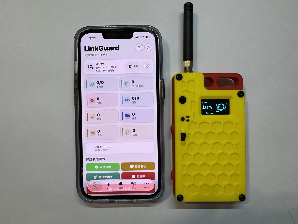
接收指揮中心下達的受困者生命徵象與任務指令;以信標訊號強度估算概略距離, 搜救員在地圖上標記受困者位置。

Receives victims’ vital signs and mission orders from the command center. It estimates rough distance by beacon signal strength, and rescuers mark victim positions on the map.

平台Platform手機 AppPhone app
測距Ranging信標訊號強度Beacon signal strength
地圖Map受困者標記Victim marking
指令Orders任務下達 / 回報Dispatch / report
搜救員手持端 Rescue Radar
待放檔案File missing 把照片存成 assets/rr.jpg 就會自動顯示。 Save the photo as assets/rr.jpg and it appears automatically.
手機 App 與手持無線終端 Phone app paired with the handheld radio terminal

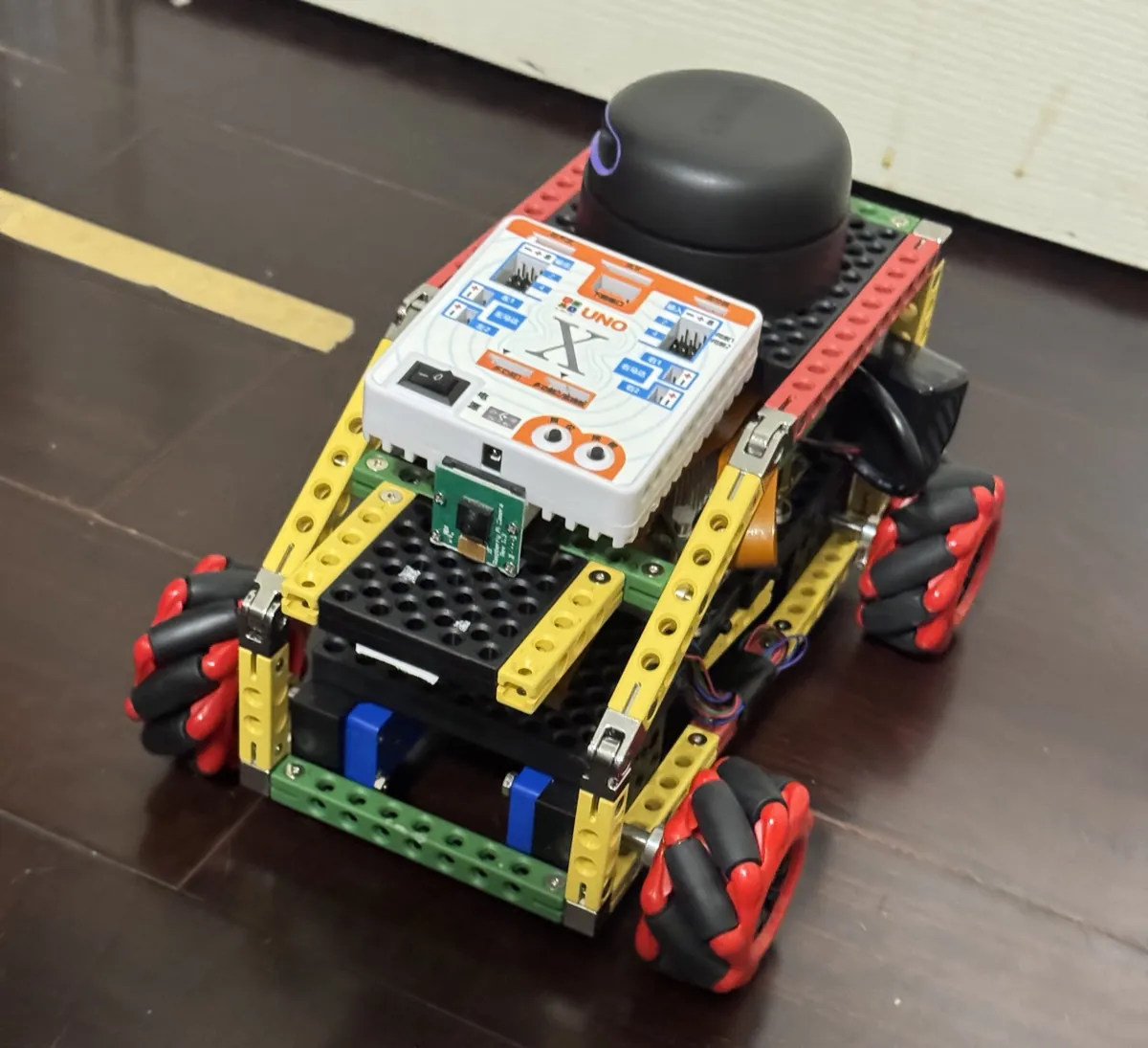
率先進入危險區域,自主行進並回傳影像與感測資料。 由機器人先行探查不穩定結構,讓搜救人員承擔更少風險。

Goes into dangerous areas first; drives itself and sends back video / sensor data. The robot checks unstable structures first, so rescuers take less risk.

任務層級Search layer地面確認Ground confirm
行進Navigation自主導航Self-driving
回傳Downlink影像 / 感測Video / sensor
續航 / 越野能力Endurance / terrain約 40 分鐘 · 平坦/輕度碎石~40 min · flat / light rubble
地面機器人 Ground Robot
待放檔案File missing 把照片存成 assets/ugv.jpg 就會自動顯示。 Save the photo as assets/ugv.jpg and it appears automatically.
地面機器人 · LoRa ESP32-S3 主控與麥克納姆輪 Ground Robot · LoRa ESP32-S3 controller, mecanum wheels

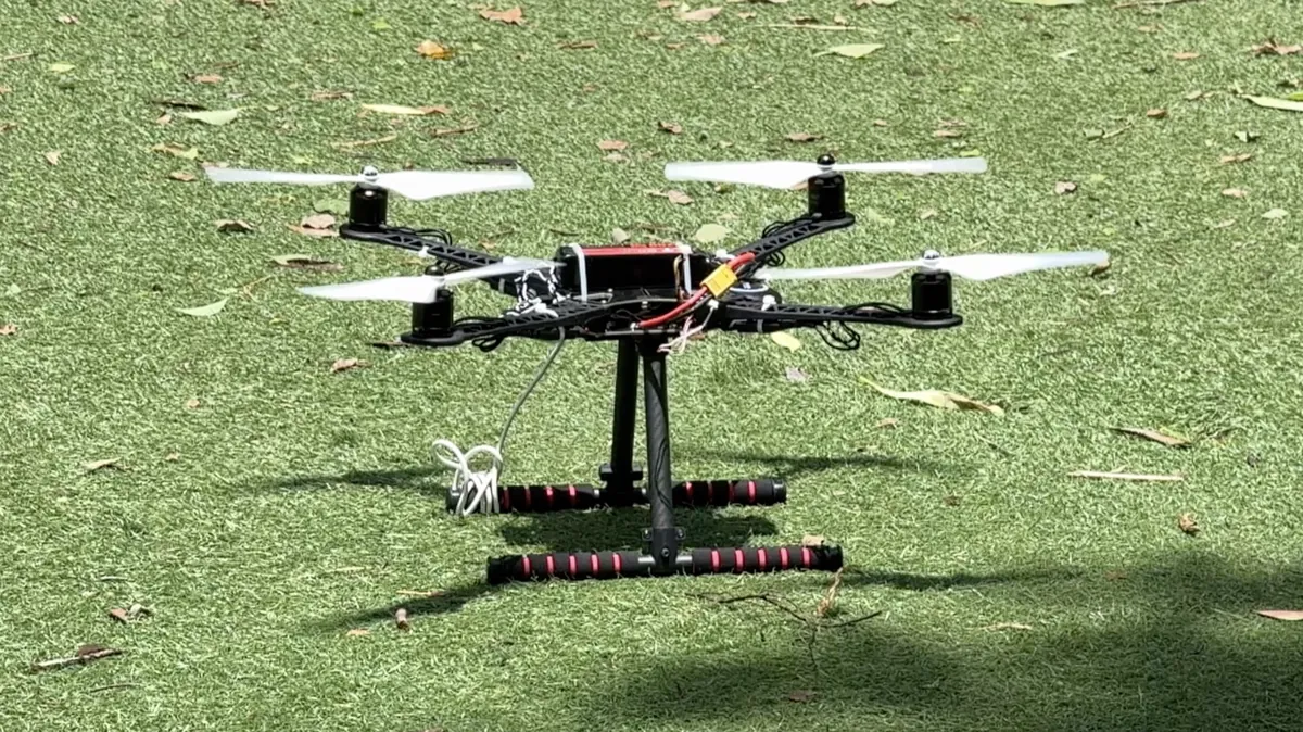
兩架無人機是一組互補的搭配,不是兩件各自為政的裝備。 定翼無人機滯空時間長、涵蓋範圍廣,負責快速掃描大範圍災區, 一旦發現目標就標記座標;四旋翼無人機接著飛抵該座標懸停近拍, 補足地面視野的死角。兩者加上地面機器人,構成「廣域 → 近距 → 地面」的三層搜索。

The two drones are a complementary pair, not two separate pieces of kit. The fixed-wing drone has long flight time and wide coverage, so it scans large disaster areas fast and marks the position whenever it finds something; the four-rotor drone then flies to that position, hovers, and films up close, covering blind spots on the ground. Together with the ground robot they form the “wide → close → ground” three-layer search.

定翼 · 任務Fixed-wing · role廣域掃描 · 標記座標Wide scan · mark position
四旋翼 · 任務Four-rotor · role近距查證 · 懸停近拍Close check · hover & film
協同Teaming空地一體 · 三層搜索Air + ground · 3 layers
作業距離 / 飛行時間Operating distance / flight time定翼 ~8 km / 40 分;四旋翼 ~1.5 km / 15 分Fixed-wing ~8 km / 40 min; quad ~1.5 km / 15 min
四旋翼無人機 Four-Rotor Drone
待放檔案File missing 把照片存成 assets/qr-drone.jpg 就會自動顯示。 Save the photo as assets/qr-drone.jpg and it appears automatically.
四旋翼無人機 · 起飛前實拍 Four-Rotor Drone · before take-off

系統通訊架構總覽

System Communication Architecture

從受困者訊號到指揮端,LinkGuard 依任務層級切分頻段,讓搜索、隊伍協作與 HQ 指揮鏈互不混淆。

From the victim signal to command, LinkGuard separates search, team coordination and HQ traffic by mission layer.

Victim 受困者節點Victim node
Rescue Mesh 搜救自組網Rescue mesh
Team Leader 隊長節點Leader node
HQ 指揮鏈節點Command-chain node
Command App 指揮應用程式Command application
BLE Rescue/HQ 節點可與鄰近 App 雙向同步狀態與指令。 Rescue and HQ nodes can synchronise status and commands with a nearby app.
910.x/911.x MHz · 搜索通訊Search 913 MHz · 隊伍命令Team commands 433 MHz · HQ 指揮鏈HQ command chain BLE · App 與節點App and node
04 — 功能說明Functionality

感測、搜索、決策 ——
三步接起斷掉的那條線。

Sense, search, decide —
three steps to reconnect the line.

滑鼠移到(或點擊)下方任一步驟,上方流程圖會高亮對應的資料路徑。

Hover or click any step below and the diagram above highlights the matching data path.

地面確認 GROUND CONFIRM 定翼無人機 Fixed-Wing WIDE SCAN 四旋翼無人機 Four-Rotor CLOSE CHECK 地面機器人 Ground Robot CONFIRM LoRa · 長距跨山 LoRa · LONG RANGE 生存信標節點 Beacon Node HR / SpO₂ 環境感測節點 Sensor Node 含水 / 坡度 / 水位 SOIL / SLOPE / WATER 指揮中心 Command Center LOCAL AI · NO INTERNET 優先順序排序 · 儀表板 PRIORITY RANKING · DASHBOARD 任務下達 · 生命徵象 MISSIONS · VITAL SIGNS 搜救員手持端 Rescuer Handheld RESCUE RADAR 受困者 Victim 標記位置 POSITION MARKED
05 — 數據與效能Data & Performance

把「可以用」變成
可以量的數字。

Turning “it works”
into numbers you can check.

四次通訊實驗測得 LoRa 最大通訊距離為 1.96 公里。

Four communication tests measured a maximum LoRa range of 1.96 km.

LoRa 可通訊距離LoRa link distance

BY TEST · 單位:公尺 (m)unit: meters (m)
系統規格一覽System specs

關鍵數字,一次看完。

The key numbers, in one place.

LoRa 距離為四次通訊實驗的實測結果;其餘為依目前排程、封包大小與耗電條件計算的設計估算。

LoRa ranges are measured results from four communication tests. Other figures are design estimates calculated from current scheduling, packet-size and power assumptions.

項目Item 規格/實測Spec / measured
LoRa 通訊距離LoRa link distance 四次實測:1.59/1.73/1.85/1.96 km;最大 1.96 kmFour tests: 1.59 / 1.73 / 1.85 / 1.96 km; maximum 1.96 km
生存信標節點電池續航Beacon battery life 設計估算:一般約 120 h/低頻 240 h/高頻 48 hDesign estimate: normal ~120 h / low-rate 240 h / high-rate 48 h
環境感測節點回報週期Env. report interval 設計值:每 5 分鐘;超過閾值立即回報Design value: every 5 min; immediate on threshold
指揮中心同時追蹤節點數Nodes tracked at once 容量估算:穩定 40 · 尖峰 55Capacity estimate: stable 40 · peak 55
地面車續航與越野UGV endurance / terrain 設計估算:約 40 分鐘 · 平坦/輕度碎石Design estimate: ~40 min · flat / light rubble
無人機作業距離與飛行時間UAV operating distance / flight time 設計估算:定翼約 8 km/40 分;四旋翼約 1.5 km/15 分Design estimate: fixed-wing ~8 km / 40 min; quad ~1.5 km / 15 min
封包傳送頻率、大小及遺失率Packet rate, size, loss 封包設計約 30–150 bytes;遺失率估算:開闊地 < 5%、邊緣 < 15%Packet design ~30–150 bytes; estimated loss: open < 5%, edge < 15%
SBN 單一節點物料成本(BOM)BOM per SBN node 設計估算:約 NT$2,000,無月租;其他模組成本見下表Design estimate: ~NT$2,000, no subscription; see the table below for other modules
成本與電力Cost & Power

模組成本與續航。

Module cost and endurance.

單套成本與續航時間均為依目前硬體配置整理的估算值。

Per-unit costs and endurance figures are estimates based on the current hardware configuration.

模組Module 單套成本(估)Est. unit cost 續航時間Endurance
SBN 生存信標節點SBN survival beacon node US$62 一般 120 h/低頻 240 h/高頻 SOS 48 hNormal 120 h / low-rate 240 h / high-rate SOS 48 h
SEN 環境感測節點SEN environmental sensor node US$83 約 50 天(2×18650、每 5 分鐘回報);含 2 W 太陽能可長期駐點~50 days (2×18650, reporting every 5 min); 2 W solar supports long-term deployment
CMD 指揮中心CMD command centre HQ LoRa 節點 US$59+平板/筆電沿用現有裝備(新購約 US$370)HQ LoRa node US$59 + existing tablet/laptop (about US$370 if purchased new) HQ 節點 60–90 h(持續接收);平板 8–10 hHQ node 60–90 h (continuous receive); tablet 8–10 h
RR 搜救員手持端RR rescuer handheld 手持終端 US$60+手機沿用個人裝備Handheld terminal US$60 + rescuer's existing phone 終端約 70 h(每 3 秒回報);手機 App 10–14 hTerminal ~70 h (3-second reporting); phone app 10–14 h
UGV 地面機器人UGV ground robot US$185 40 分鐘(平坦/輕度碎石,2S 3,000 mAh,平均 4.5 A)40 min (flat/light rubble, 2S 3,000 mAh, 4.5 A average)
UAV 空中載具UAV aerial vehicles 四旋翼 US$400/定翼 US$555Quadcopter US$400 / fixed-wing US$555 四旋翼 15 分鐘・1.5 km;定翼 40 分鐘・8 kmQuadcopter 15 min · 1.5 km; fixed-wing 40 min · 8 km
效能情境Performance Scenarios

壓力、斷線與成本。

Load, link loss and cost.

以下依現有系統參數估算不同負載下的預期行為與規模差異。

The following estimates use the current system parameters to compare expected behaviour under different loads.

評估項目Evaluation 條件Condition 預估結果Estimated result
10 節點負載10-node load 一般回報+隨機 1 個 SOSNormal reports + one random SOS 封包抵達率 98.6% · P95 延遲 1.2 s98.6% delivery · 1.2 s P95 latency
25 節點負載25-node load 一般回報+同時 2 個 SOSNormal reports + two concurrent SOS 封包抵達率 96.8% · P95 延遲 1.8 s96.8% delivery · 1.8 s P95 latency
40 節點負載40-node load 一般回報+同時 4 個 SOSNormal reports + four concurrent SOS 封包抵達率 93.5% · P95 延遲 2.7 s93.5% delivery · 2.7 s P95 latency
BLE 斷線BLE link loss 手機離開範圍 30 s 後返回Phone leaves range for 30 s and returns LoRa 持續運作 · 預估 5–15 s 重新連線並同步狀態LoRa remains active · estimated 5–15 s reconnect and state sync
節點遺失Node loss 單一中繼節點停止回報One relay node stops reporting 30 s 標記逾時 · 其他節點繼續通訊Marked timed-out after 30 s · other nodes continue
HQ App 斷線HQ App link loss BLE 暫停 60 sBLE unavailable for 60 s HQ LoRa 鏈維持接收 · App 重連後同步最新狀態HQ LoRa continues receiving · latest state syncs after reconnection
估算基準:L4 Profile、30–150 byte 封包、既有角色回報週期與 18 個搜尋頻道;各負載情境以 10 分鐘任務窗口計算。 Estimate baseline: L4 profile, 30–150 byte packets, current role-report intervals and 18 search channels, calculated over a 10-minute mission window for each load case.